
← Return to Age of Exploration Main
Age of Exploration Websites and Videos for Students
Looking for Age of Exploration websites and videos to share with your students? If so, this is the list for you. It is a roundup of engaging and informative websites and videos for students all about the Age of Exploration.
Kids have access to see, listen to, and read about more than ever before. We can leverage that to our advantage! When we partner with students as they explore the digital realm of the world, we can provide the guidance and tools they need to learn to safely navigate it. You can read more about using websites and videos in the classroom here.
If you’re ready to dive into this list of websites and videos, you can click through the navigation below or keep scrolling. Click on the images to access the resources listed. Be sure to preview all resources to determine age-appropriateness before sharing them with your students.
Jump to:

Looking for more Age of Exploration resources?


Videos
National Geographic’s “Manhattan: What Henry Hudson Saw in 1609”
This video shares images of present-day Manhattan then fades away to a rendering of what Manhattan might have looked like prior to European contact. See the example of Foley Square prior to European arrival pictured on the screenshot to the right.

Gilder Lehrman’s “How was North America Settled Before European Colonization?”
“One of the mistakes that early Europeans made is the Europeans looked at this landscape and in their words, they saw a wilderness. The Pilgrim Governor William Bradford in 1620 looking out at modern-day Massachusetts said that the Pilgrims had arrived and they had come into a vast wilderness filled with ‘hideous beasts and hideous men’. They didn’t know what multitude there were of them…. But in fact, what Bradford saw and what other Europeans saw was a world that had been shaped very consciously, very decisively by people who’d been there for generations.”

Ted-Ed’s “The Atlantic Slave Trade: What Too Few Textbooks Told You”
This video gives a straightforward yet powerful overview of how the Atlantic Slave Trade came into being, a high-level summary of what it involved, and a brief picture of its lasting impact on the world.
This is a video you will definitely want to preview before sharing it with students. You could consider sharing snippets of it, such as beginning the video at 3:55. At 3:55 in the video, the narrator describes the impact of the Atlantic Slave Trade on Africa’s future and the racism that was born out of it.

Cartography of the Past vs. Present
Connect the cartographers of the past with those of the present by exploring how Google creates its maps. “Google collects Street View imagery by driving, pedaling, sailing and walking around and capturing imagery with special cameras that simultaneously collect images in multiple directions. The images are later overlapped and stitched together into a single 360-degree image.” - Google

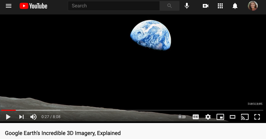
This is another neat video made for kids explaining how Google Earth’s images are made. “Google Earth is the most photorealistic, digital version of our planet. But how?! Where do the images come from? How are they put together? And how often are they updated? In this video, learn about the pixels, planes, and people that create Google Earth’s 3D imagery.” - Nat & Friends YouTube.com Channel
TED-ED’s European Exploration and the Caravel
If you can get past the narrator’s voice, this 1.5 minute animated video is an easy way to share an overview of the caravel with your students.

Key Explorers & Voyages
Google Earth’s Explorer Routes
“During the late fifteenth and sixteenth centuries, knowledge of Earth’s geography grew in leaps and bounds. Christopher Columbus, John Cabot, and Amerigo Vespucci introduced the Americas into recorded history. Vasco da Gama was the first European to sail through the Indian Ocean to Asia, and Ferdinand Magellan and Francis Drake circumnavigated the globe.” This interactive Google Earth map tracks the routes of these early explorers.

The Maritime Museum & Park’s Map and Image Gallery
You can sort by explorer, ship, voyage, or tool to find a wealth of resources about each of these topics from the Age of Exploration. There are interactive maps, such as the one pictured on the right, along with written descriptions and images of key ships, explorers, and tools.

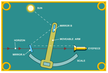
PBS’s How a Sextant Works
“There's nothing mystical or complicated about a sextant. All it is is a device that measures the angle between two objects.” Using a few simple visuals (like the one shown on the right), this webpage shows how a sextant works as a navigation tool.
After you look at the diagram of a sextant by clicking the image to the right, you can read about how to use a sextant here.
Interactive Features & More
PBS’s The Columbian Exchange
“In this interactive lesson supporting literacy skills, students watch video dramatizations that tell the story of the Spanish explorers who arrived in the Americas with Columbus and introduced European, African, and Asian plants and animals to the Western Hemisphere. Students develop their literacy skills through a social studies focus on how the Columbian Exchange impacted life on both sides of the Atlantic. During this process, they read informational text, learn and practice vocabulary words, and explore content through videos and interactive activities.”
